Greetings, digitalists,
In my last blog entry, titled “Space and Place in Literature: Reflections on Mapping the Medieval Icelandic Outlaw Sagas,” I shared my three main methodological takeaways: allow time to really determine the question(s) driving your research, look for methodological and software-based flexibility, and make sure you implement a system to manage your data for maximum replicability.
After following these three steps, I had a set of cleaned-up data on place names in the Icelandic Outlaw Sagas ready for transformation and analysis. So, what did I create from this data, and how was I able to interpret my findings?
GEOCODING
My first experiment consisted of mapping the points in a traditional sense: using an actual map compatible with Geographic Information Systems. With the richness of geography in the sagas, my mapping instinct is certainly not unique–there are many wonderful mapping projects on this body of literature already in existence. Work such as Emily Lethbridge’s Saga-Steads exploration and forthcoming digital mapping project, as well as the Human Ecodynamics Research Center’s examinations of mapping, material culture, and anthropological themes in the North Atlantic, have already proved their value in the study of the geographic and material world of the sagas. It is my hope that the data I have obtained in my studies will be of use to these excellent researchers and their projects, and also available for further exploration in ways that I have not yet imagined. Stay tuned to this blog for updates on when the data set of place names and their metadata is posted–they will be available for download and open source use (with citation).
To return to my own iteration of a saga mapping project: for my geocoding, I needed to develop a protocol to determine place name location with the greatest degree of accuracy possible (without physically checking each point in Iceland, although I hope to add fieldwork in future work on this project). After extracting a list of 427 discrete place names throughout the three sagas by transforming my XML markup into tabular data, I found each point by cross-referencing Google Earth, search engine queries, and the enormously helpful National Land Survey of Iceland’s place name tool, recommended by Hallgrímur J. Ámundason at the Onomastics Department at the Árni Magnússon Institute in Reykjavík, Iceland. I was able to geographically map 346 locations: an 81% rate of completion, which could certainly be improved upon with field work and further research. The high rate of completion in this project highlights the continuity between medieval Icelandic place names and their modern counterpoints—a feature of the Icelandic landscape and language that initially drew me towards geographic analysis of the sagas.
After mapping my points in the open-source software QGIS (where ‘Q’ stands for Quantitative), I then used the data from the project’s shapefile, alongside the rich metadata I had gathered, to create a web-based, interactive map with the JavaScript library Leaflet. The resulting map has numerous components—click on the title below to open the link.
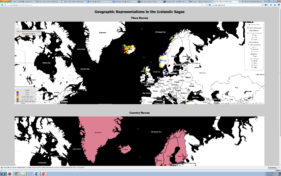
The points are color-coded according to their mentions in sagas—or mentions across multiple sagas. Clicking on a point creates a pop-up that shows how many times the place name is mentioned total, with a break-down according to its presence in each saga.
On the whole, I felt that country mentions in the sagas functioned in a slightly different manner than other place names—invoking a farmstead, for instance, carries a different semantic weight than a country, particularly in the medieval period—and this perhaps deserves further specific study beyond my current research. Nevertheless, I have included a map of country names mentioned since they still invoke place, which is featured below the place name map. Clicking or hovering over a country will reveal its number of mentions and their corresponding sagas.

On the place name map, results may also be filtered according to feature category with the legend on the right-hand side of the browser. This data derives from moments in a saga when a place name also includes a feature category either within the name or syntactically close to the name—such as a glacier, fjord, or homestead. Features may be sorted according to their association with water, landforms, or human-created spaces, the latter of which I have named social features.
FINDINGS
I found the range of place names that were mentioned particularly interesting; the map contains points as widespread as Constantinople (Grettir’s Saga) and the Nile River (The Saga of Hord and the People of Holm), as well as more traditionally North Atlantic and Scandinavian places such as Trondheim, the Scottish Firths, and Reykjavík. The spread of locations is impressive, and reveals the sagas’ investment in depicting the cultural awareness, rather than isolation, of the Icelandic people as well as its Viking heritage of travel and exploration.
I will be interrogating this map for further patterns and data in the following months. However, the execution of this map, and all future interpretations of its data, rests upon a methodological question: what precisely is gained in mapping the place names of the outlaw-themed sagas—Grettir’s Saga, Gisli’s Saga, and the Saga of Hord and the People of Holm—geographically, and is this even a possible task? General objections to geographic representations of literature center on the idea of fiction as representative of purely imaginative, rather than physical space. However, questions of historicity versus literariness have transformed into a more productive conversation, one that that Margaret Clunies Ross details well:
“In recent scholarship on the Icelandic sagas, the emphasis has shifted from an older attitude that sought to classify sagas as either history or fiction, but not both, to an approach that allows the two creative impulses, historical and fictional, to coexist in any text in a variable relationship, both within a single text and between texts” (“Realism and the Fantastic in the Old Icelandic Sagas,” Scandinavian Studies 74:4, 2002).
As per Ross’ thesis, when we engage in the tangible possibilities of literary space we do not deny its imaginative components of literature, but rather acknowledge the interconnectedness of mental and physical experiences of place. However, if scholarship is to truly account for the dualities and interplay between geographic and imaginative space in literary works, how do we account for literary usage of place name beyond its potential for geographic data? How does place name function in a literary sense—that is, syntactically and semantically—and how does the answer to this question affect our understanding of space in literature?
I look forward to refining the aesthetic, interface, and even data of this map as I attend the City University of New York Graduate Center to begin work on my PhD. But to move right along: in my next post I will share my attempts to visualize the question of imaginative space using further place name data from the outlaw-themed sagas that I have collected.
In the meantime, please do enjoy the geographic component to this project—and feel free to share your comments via the blog or email at mck2158@columbia.edu.